canal bank road
I did a moderately-to-severely dumb thing today.
It started when I got into a wikihole and ended up on the page of the Chicago Sanitary and Ship Canal. It’s a fascinating piece of civil engineering, the thing that enabled the reversal of the Chicago River, a project which kept Lake Michigan from turning into the planet’s largest open septic tank.
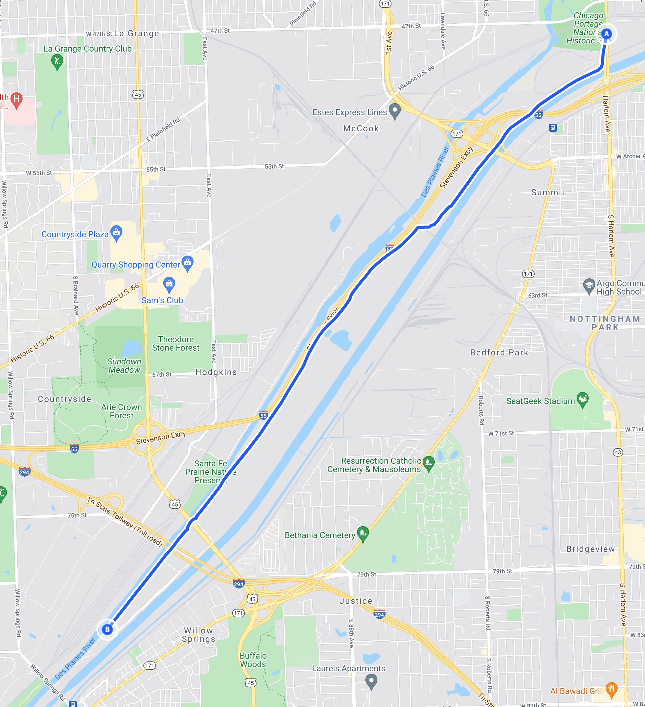
From that wiki, I bopped over to Google Maps, and after zooming in far enough, Canal Bank Road caught my eye. It’s a service road which runs for about six miles between the CSSC and the Des Plaines River. I’ve lived in this area for all of my 54.4 years, and never really spent any time exploring the various waterways. I’m not a boat guy; I’m a barfing landlubber. But they are such an essential part of what this region is about, this nexus of Great Lakes and Mississippi River shipping, and the nation’s railway hub. And so much history, too. The waterways here are why there were native settlements going back for millennia, and they are also how the first non-native explorers and eventually European settlers found their way here to commit genocidal atrocities. It seems like something with which I should be more closely acquainted. And I had time to kill and a sunny afternoon before me, so I got in my car for a brief adventure. Maybe this would be an interesting running route. Maybe I’d take some pictures.
Or maybe I’d be too freaked out to even get out of my car, and wish I’d spent the afternoon watching baseball and golf.
Entering the road just off of Harlem, south of 47th street, I was soon greeted by a number of signs indicating just how completely unwelcome trespassers were, and how vigorously they’d be prosecuted if caught. You see these signs everywhere around here, especially around rail yards, and honestly most people don’t pay them a lot of mind. They seemed especially unthreatening given that they didn’t say exactly who owned the land and would be doing the prosecuting. And there were no gates or fencing. You want to keep me out, you need to work at least a little bit harder than that.
Mile 1. I see a wave of signs that claimed the area was under 24-hour video surveillance, and that illegal dumping would be prosecuted with extreme prejudice. So it’s as I thought, they just want to scare away dumpers, and, more likely, kids coming here at night. I see no people or vehicles anywhere, but there are a lot of interesting wetland birds. The canal sits to my left, dead calm, and to my right, a grassy area. I can’t see over it, but from the satellite map, I see that it’s an area owned by the Metropolitan Water Reclamation District. All of this land is, it appears. This makes sense. Comfortable with my decision to ignore the various No Trespassing signs and other warnings, I press on to the southwest, knowing that this is government land, but not the scary kind like Area 51 or the IRS. The risk is low. As I pass under I-55 (and I mean way under it, that bridge is really high), suddenly a hard cold front moves in, and clouds obscure the sun. Hmm.
Mile 2. The road is poor, at parts unfinished gravel; at others, ancient, cracked concrete with weeds sprouting forth right down the centerline. The road braids with a decrepit set of rusty railroad tracks, parallel mostly, but with several long crossings as the tracks bisect the road at the most obtuse angles. There are no control gates or signals, and even though the tracks seem unused for decades, I slow and stop at each crossing. The canal still sits placidly to my left, and now to my right I observe the first set of black fields. Some are old and flattened by the weather, others have rows of coal-black matter that appears to be freshly dumped from trucks. They look like pure topsoil or compost, but the smell isn’t right. I’m pretty sure, given that this is MWRD land, that these are sludge fields, the final step of the sewage treatment process. I veer west and am now driving along I-55, separated by a wooden fence I’ve seen a million times from the other side. On my left, I see what appears to be a reservoir, deep and dark. I slow to take a look, and a red-winged blackbird atop the fence screams at me. He knows I don’t belong here. I roll up the windows and pick up speed.
Mile 3. The road suddenly improves, though it’s potholed, as if heavy trucks use it. I round a bend and am greeted with the ugliest orange sign I have ever seen. DANGER, BLASTING AREA, and a long list of radio frequencies to avoid using lest I trigger an inadvertent explosion. Even though I haven’t seen a soul, and I know those frequencies are nowhere near the commercial devices I use, I turn my phone off. I glance sideways at the car radio. The deepest limestone quarry I have ever seen comes into view, and the only thing separating Canal Bank Road from a drop of perhaps 1000 feet is a chain-link fence. The plan had been to continue southwest on this road for about six miles, where it intersects with Willow Springs road. I would turn off there, cross the river, and be back in suburbia. The quarry and the dynamite threat afford me my first inclination to turn back to the northeast and escape whence I came, but I knew I was about halfway in, and I felt it was a 50/50 choice to go forward or back. I opted to go forward. Fool.
Mile 4. Past the quarry now, on my right, I see an administration building. There are at least ten MWRD police vehicles there, and for the first time I felt real fear. Dynamite and ominous birds are one thing; suburban cop wannabes, accountable only to a pseudo-governmental entity nobody understands, three miles from anywhere, are quite another. If any of them spotted my Chevy Bolt cruising down this road reserved for treated shit management and limestone transport, I’d surely get the rubber-hose-in-a-steel-room treatment. I debate speeding up, but the road is poor again, and I wonder if the cops up there, like reptiles, are more likely to detect motion. I opt to continue my sub-10 mph cruise. I note it’s been a long time since I’ve seen a No Trespassing sign, or threats to prosecute dumpers. I’ve breached the inner perimeter. Mercifully, MWRD police don’t see me, though I wonder if there’s a network of cameras or sensors that might. (In retrospect: dude, it’s a sewage treatment plant, what do they care?) I turn my phone back on, hoping the Find My Phone feature will lead rescuers or lawyers to me.
Mile 5. Vast fields of sludge now on my left, some fallow and flat, some still mounded high with fresh dump truck tire prints along side. If you’ve driven past one of these, you know the smell. It’s sickly sweet, something like rotting potatoes. It’s uncomfortable from the distant highway at 70mph, and something much harder to bear from 50 feet at a fraction of that speed. I pass under I-294 and through the absolutely massive construction site where they are moving the Mile-Long Bridge a few feet over for some reason. Again, I expected this to be the point where I was intercepted by either tollway police or private security guarding the site, but I encountered no people. I’m sure if I tried this on any other day of the week I’d be awaiting a bail hearing right now. I pass hole drillers and pile drivers bigger than I’ve ever seen before, and a fleet of gigantic construction vehicles. It’s gotta be worth nine figures. Frankly I was shocked there weren’t armed guards here. Was there an I Am Legend event in the last twenty minutes?
Mile 6. Almost out. My muscles are tense, my heartbeat elevated, my breath unsteady. I want this to be over, and it almost is. What seemed like a lark had turned into something stupid, bordering on dangerous. The canal and the river begin to converge here, and as I pass the last sludge field, the strip of land is no more than 100 feet wide, now, with my road running down the middle. I’ve long since stopped noticing the dark stillness of the water, the interesting birds, the sludge piles, the cops, the mining trucks. I am less than a half-mile from suburban comfort again. And it’s here I encounter my first locked gate. End of the road. Game over. I can travel no further to the southwest, to my freedom from this semi-industrial otherworld I stumbled upon. The only choice is to go all the way back, the way I came. Past the police station, the acres of shit-sludge, the quarry, the dynamite, the black loch and its lurking demons, the goddamn red-winged blackbird, and probably a raven screaming “nevermore,” why not.
Fortunately, less than two miles into the return journey, now fully on edge, I found a construction entrance/exit and escaped onto Lagrange Road. It was a bit of a tricky merge from 0-65 on a gravel shoulder, but you gotta do what you gotta do. A second pass past that police station wasn’t going to have a happy ending. I’ve never been so grateful to get back to the strips of gas stations and convenience stores of the southwest suburbs that flank the canal and river. The space outside those two waterways isn’t pretty, but it’s known. The space between them is purely unknown, maybe unknowable. I’m not going back.